Having entered the Tour de Helvellyn, a 37 mile trail/fell running event in December, I decided it would be wise to spend some time on the route to familiarise myself.
I kinda know the circle bit from Glenridding over to St John Vale then to Grisedale Tarn and back to Patterdale, but I hadn't the faintest clue about getting from Askham, where the race HQ and start finish is, to Patterdale.
By coincidence, I had been to Askham a week earlier and took a walk up onto Heughscar Hill then down to the Cockpit. from there I know the route to Howtown, so its only really the stretch from Howtown to Patterdale I wasn't familiar with.
A plan was hatched. I would be dropped off in Askham with my dog, food, drink and camera, and be collected several hours later in Glenridding. Yes, this was to be a do or die excursion....... either I'd navigate successfully through the great mountain ranges and valleys of the East of Ullswater fame..... or be forever lost in their midst, and fall prey to the hungry Eagles and Roe Deer that hunt therein.
Alighting the motor car I was immediately confronted by the cold of the winter. I donned my waterproof top and £80 gloves and set off up the same track as I had first set on a week before.
Although my plan was to run to Glenridding, this wasn't so much a training run as a day out with camera for any photo opportunities, and map, to continually check my progress. So I stopped within a few minutes to revisit some shots I'd taken the week prior. The location was sheltered in trees and I wondered why so much dripping water was landing on me. The photos weren't up to much and as I ran on again I realised the weather had changed significantly. It was snowing. Cool.
Within minutes the pretty snow had become a complete white out and I ran at pace down to the track that connects Pooley with Helton. At the cairn that marks the right turn in the L50 or the DITL race there are currently some huge bails of harvested bracken. Sheltering between these bails I unpacked my waterproof trousers and mentally prepared for cold, wet couple of hours ahead.
As we set off toward Howtown poor Scamp had white sides where the driving snow stuck to his bony ribcage. He seemed oblivious however, and kept up his usual habit of finding sticks of various dimensions for me to throw for him. Scamps attitude to sticks is hilarious. It can be so small that it doesn't stick out the side of his mouth, and so thin that it snaps in two as he bites it... or so large that he is unable to carry it properly and is forced into a funny sideways motion with a metre or two of branch following behind. A stick is a stick in Scamp world and must be given to Steve to throw for his retrieval.
It was a near blizzard. I WASN'T CHUCKING ANY BLOODY STICKS.
As I ran I constantly shook the snow from one arm. Just the one. One sleeve of my jacket was neatly gripping the outer of my £80 gloves. But once I had donned one glove it was then impossible to similarly arrange the opposite sleeve in the same manner because of the thickness and mitten-style of the gloves. This meant water and snow (same thing really) would potentially run down my sleeve into my glove. Unless I shook it.
We battled on thought the blizzard for what seemed an eternity. In such conditions you tend to lose track of both time and distance, but I suspect we covered at least six, if not eight or nine hundred metres before the storm abated and the sun came out.
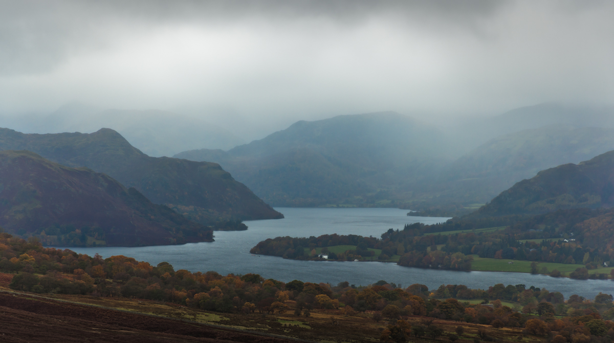
After that it was gloriously sunny for the rest of the day. So nice in fact that I then stopped so frequently for photo opportunities that it took about 3 hours to cover what I reckon is only about 10 miles.
 |
| First photo stop and its my old friend Miss Blencathra looking rather sexy in her winter coat |
Most of my stops were along the section to Howtown........
 |
| Stop #2 - So much better than last weeks (Joke by B. Forsyth - see below) |
 |
| Last weeks |
Running without a tripod and full range of camera gear, I knew that all the photos I was taking would be compromised in various respects. A lack of depth of field necessitated by handholding speeds. Noisy image from higher ISO used to counteract. Camera shake still evident on close inspection. Filter ideally needed for the range of contrast. Typically, the next day, when I had all my gear on a short walk up from Keswick, the snow had melted a little, and the light was much less special.
 |
| 90 secs after packing it away I rushed to get camera out again for stop #3 |
Eventually I reached Howtown. Studying the map I realised I needed to get over the wee pass into Martindale. The road to Martindale is the zigzaggy one that rises up steeply from Howtown and looks a bit like it should be in the Pyrenees. Theres also a good pathway to Martindale which is the route at the end of the offroad section of the DITL run. I took the path which saw me arrive in Martindale and another choice.... go up the Howe Grain valley a short distance then sharp right off to climb over Howesteadbrow, or use the main road into the Boredale valley? I was wearing my fellshoes so opted for the off road footpath. Looking at the map it would be shorter to use the tarmac road from Howtown all the way up into Boredale, but at present I dont know if the route is strictly off road when available, or if you can choose your own way between the checkpoints.
Boredale. Never been there before, unless you count those 50 times with Penrith Stu. Oh no, hang on. Time spent with Penrith Stu isn't BoreDALE, it's BoreDOME.
The road up the centre of Boredale is quite straight and eventually at Boredale Head gives way to an equally straight path. You therefore get a long long look at the inevitable climb out of the bowl of the valley to Boredale Hause. From a distance it looks like it will be a killer climb but to be honest its a gentle enough slope and on a wide path until the very topmost section.
At Boredale Hause there is a myriad paths crisscrossing the fell. Which one to take to Patterdale? I checked the map and noted the bearing for the path I wanted. Also, as long as you go to the right, and not uphill, you will be going the correct way. Also also, I asked a runner coming up toward me if he had come from Patterdale - he had.
So I dropped down to Patterdale, stopping before I lost too much height for the final photo of the day......
 |
| Patterdale. Grisedale Brow in the sun - the famous 'Hole in the Wall' route to Striding edge. Also just visible is the pointy top of Catstycam |
The rest, as they say, is history. Drop down into Patterdale village, pop up the valley half a km to meet the runners coming toward me as they neared the end of the Helvellyn trail race, then follow the race route to Glenridding, bump into Phil Windchill and Dobbo, (Cumbrias 2nd best race photographer) for brief chats, all in perfect time to wash Scamp in the (bloody freezin') river and get my lift home.
A quite superb way to spend a Saturday.
------------------------------------------------------------------
Sunday was the Derwentwater 10 mile road race. Having missed so much hard road training of late I wasn't really interested in 'racing' this race and planned to get round in a half decent time without putting myself too far into the red, then build upon the effort in a bid to race much harder at Brampton two weeks later. The first 2 miles actually felt quite hard as I tried to stay on Millys heels. I wsa distanced but fought back up to him by mile 3. By mile 5 it all felt much easier and we were heading for I reckon about 60-61 minute result. I took it real easy for a couple of miles then pushed on harder again until mile 9, when I eased down considerably to avoid getting into a contest to beat or outsprint anyone. About 62:30 result is nothing special (and about 7 mins slower than my course pb).
 |
Pre race walk up to "the landing" on the Latrigg path for some tripod/filter work
ISO 100, f/11, 1/40sec, 100mm prime on Full Frame |
This photo (above) is so sharp you can actually see Pete Richards making a cuppa tea on his boat in the Nichol End Marina (disclaimer - it may have been a cuppa coffee or even hot chocolate)
 |
Razor sharp results but less snow, less drama than Saturday.
ISO 100, f/11, 1/15sec, 100mm prime on Full Frame |
Joke Explanation - Compere of the long running ITV hit quiz show Play Your Cards Right, Sir Bruce Forsyth used to say every week how lovely the audience were and how they were "so much better than last weeks".
The reason this is funny becomes obvious once you know a little about how TV shows of this type are made....
Despite the show screening on our TVs just once per week (Friday night I think it was), they would actually record several 'episodes' of the show during the course of a day. This allowed a full series to be filmed in a week or so, saving on not just production costs, but it also meant Sir Bruce could appear on British screen throughout the winter, thus keeping up his fame and status as Britains favourite all round compere/comedian/light entertainer (though I personally preferred Bob Monkhouse (RIP)), whilst only having to commit to a weeks filming in August.
Bear with me - I'm about to get to my point.
The assembled audience for the show would also sit through all these multiple recordings, changing where they sat after each episode was completed. (so that blue rinse Betty in the front row didn't appear in the same seat again and give the game away to the once weekly TV audience at home).
So when Brucie came on set to rapturous applause and delivered his line, with that tongue in cheek roguish playboy manner, mixed with deadpan sincerity only he can truly pull off, the audience would literally fall about laughing as they realised the cleverness of his gag would be lost on the millions but made complete sense to the couple of hundred seated special ones who may not have previously known how TV world works but were now very much a part of that magic.
If, like myself you take great interest in how films and TV shows are made/directed etc you may now be wondering why you just wasted the last 30 seconds of your life reading this.
But on the other hand, if you have lived for the last 30 years with a little niggle buried deep inside your brain, wondering why Bruce said the same apparently quite weak joke week after week, and why it went down so well in the studio. Well now you can rest easy - no need to thank me - always happy to help.


